General Information
Natural gas consists of combustible hydrocarbons which are gaseous at ordinary temperatures and pressures, and have essentially the same origin as fluid hydrocarbons. Methane (also called marsh gas) and ethane are commonly the chief constituents. Most natural gases usually contain small and variable quantities of carbon dioxide, carbon monoxide, sulfur dioxide, hydrogen sulfide, nitrogen, hydrogen, and oxygen. In the absence of sulfurous compounds, natural gas is colorless, nearly odorless, and, when mixed in certain proportions with air, is highly explosive. An odorant is added before gas is sold to the public to aid in detection of gas leaks.
Natural gas resources can be categorized into two main types on the basis of producing rock characters: conventional natural gas and unconventional natural gas. Conventional natural gas is produced by a well drilled into a geologic formation in which the reservoir and fluid characteristics permit the natural gas to readily flow to the wellbore. Unconventional natural gas does not exist in these conventional reservoirs - rather, this natural gas takes another form, or is present in a peculiar formation that makes its extraction quite different from conventional resources. The major unconventional gas resources in U.S. include tight gas, shale gas, and coalbed methane (CBM). The latter two types are present in Arkansas.
Introduction
Natural gas was first discovered in 1887 at Fort Smith, but commercial development did not begin until 1902 when two gas wells were completed near Mansfield in Sebastian County. Gas was first discovered in southern Arkansas on April 22, 1920, when the Constantin Oil Company completed a gas well near El Dorado in Union County. The heating value of gas varies from about 700 to 1,200 British thermal units (Btu) per cubic foot. Dry natural gas from the Arkoma basin fields has a heating value of 986 to 1,016 Btu per cubic foot, and is used principally as fuel.
Conventional Gas
Major accumulations of natural gas are present in two areas in Arkansas – the Arkoma basin and the southern Arkansas oil fields in the West Gulf Coastal Plain. Natural gas is commonly discussed as either "wet" or "dry" gas. Wet gas contains some of the heavier fluid hydrocarbons as vapor, is commonly associated with petroleum, and is valuable because of the extractable hydrocarbon liquids it contains. Most gas from oil fields in southern Arkansas is of this type. Dry gas differs from wet gas in that it does not carry appreciable amounts of the heavier hydrocarbons as vapor. The gas of the Arkoma basin in west-central Arkansas is of this type.
Arkoma Basin
The Arkoma basin is an elongate sedimentary basin extending from east-central Oklahoma into Arkansas. It includes, but is not restricted to, the Arkansas River Valley physiographic region of western Arkansas. Due to the extremely high thermal maturation process over geological time, only dry gas is produced in the conventional sandstone reservoirs of this area.
The Atoka Formation of Pennsylvanian age contains the principal gas-producing units in the Arkoma basin. The Atoka Formation is a succession of alternating beds of sandstone and shale with a maximum subsurface thickness of approximately 15,000 - 20,000 feet in this region. Some dry gas has also been produced from the Morrowan Series (Bloyd and Hale formations), which underlies the Atoka Formation. Atokan and Morrowan beds have been folded into numerous east-west trending open folds which trap the gas within porous beds. Pre-Pennsylvanian reservoirs including Ordovician-age rocks in the Arkoma basin have been sporadically tested to determine their potential for natural gas. As of 2016, there are 150 gas fields that have been identified, and 7,473,695,188 Mcf of gas has been produced in the Arkansas portion of the Arkoma basin. Annual 2016 gas production data in the Arkoma basin is estimated at 75,002,726 Mcf.
During the past 45 years, at least a dozen scattered, small gas fields have been discovered in Washington, Madison, and Benton Counties in northwestern Arkansas. Production in this region has come from five formations of Late Mississippian to Middle Ordovician age.
Southern Arkansas
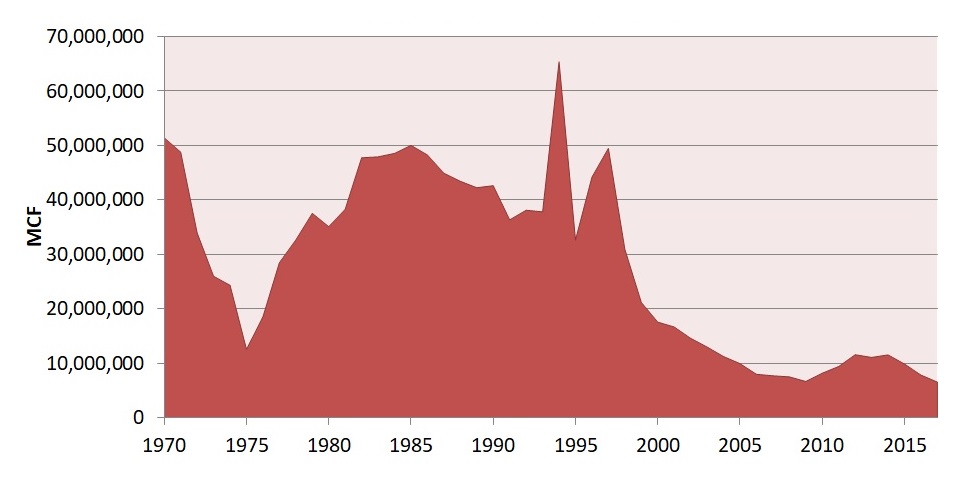
Natural gas has been recovered, commonly with oil, in the southern Arkansas oil and gas fields in Ashley, Bradley, Calhoun, Columbia, Hempstead, Lafayette, Miller, Nevada, Ouachita, and Union Counties. Annual gas production for 2016 is compiled from 354 fields in south Arkansas and is estimated at 7,831,679 Mcf of gas.
Unconventional Gas
Unconventional gas has grown in importance as a complement to conventional fossil fuel as world demand continues to increase. The Energy Information Administration (EIA) expected U.S. production from unconventional gas sources to increase more rapidly than conventional gas production. In its long-term forecast, the lower 48 states unconventional gas production grows from 6.6 Tcf in 2003 to 8.6 Tcf in 2025, and from 35% of total production in 2003 to 44% in 2025.
Coalbed Natural Gas Methane
Coalbed natural gas or coalbed methane (CBM) is the methane gas contained in coal seams. The coalification process begins with plant material that is progressively converted to coal. This process results in large quantities of methane-rich gas that is generated and stored within the coal. The presence of this gas has been long-recognized due to explosive outbursts associated with underground coal mining. Only recently has coal been recognized as a reservoir rock and a source rock, thus representing an enormous undeveloped "unconventional" energy resource. Because of its large internal surface area, coal stores between six and seven times more gas than the equivalent rock volume of a conventional gas reservoir. The United States is expected to have 700 Tcf of CBM, compared with its conventional gas reserves of 187 Tcf.
The development of Arkansas's coalbed natural gas resources began in 2001 and has yielded an approximate cumulative production of 29.5 Bcf by 2016. Estimated 2016 annual production of CBM is approximately 1.15 Bcf. EnerVest Operating LLC acquired all CMB wells in 2009 from CDX Gas LLC, who was previously the only producer of this resource in Arkansas until it filed bankruptcy in late 2008. Another active operator, Ross Exploration Inc., has commenced CBM production in Arkansas since 2009 and possesses 3 producing wells to date. The wells are completed in the Pennsylvanian Lower Hartshorne coal and approximately 564,238 feet of horizontal pinnate lateral has been drilled in Arkansas. On average, approximately 15,000 feet of horizontal lateral is drilled for each of CDX’s Z-pinnate wells in the Lower Hartshorne coal.
Fayetteville Shale Gas
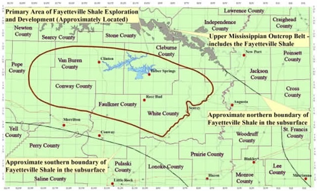
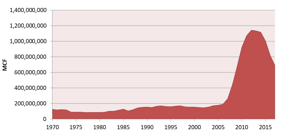
The Fayetteville Shale Formation (Upper Mississippi) has been the current focus of a regional shale-gas exploration and development program within the eastern Arkoma Basin of Arkansas since 2004. Estimated cumulative production of gas is 7.34 Tcf as of 2016. Annual 2016 production from the Fayetteville Shale producing regions is reported as 745 Bcf by the Arkansas Oil and Gas Commission. The thickness of the producing zone ranges from 50 to 550 feet and wells range from 1,500 to 6,500 feet deep.

Since the play's inception, the Fayetteville Shale play has been dominated by a small number of large players. Three operators - Southwestern Energy, BHP Billiton, and XTO Energy (a subsidiary of Exxon Mobil) - accounted for over 99% of gross operated production from the field. The three companies hold close to 2 million net acres under lease in the play. Southwestern, with 918,535 net acres and more than four thousand producing wells, is by far the largest operator among the three companies, and accounts for about two-thirds of the field's total production volume. In 2016, Southwestern's operated wells had an average completed well cost of $2.8 million per well and an average horizontal lateral length of 5,547 feet. Exxon and BHP are approximately equal in terms of their acreage and gross operated production. During 2016, Southwestern contributed 558 Bcf in Fayetteville gas sales, good for 75.0% of the play's total sales that year. XTO Energy sold 95 Bcf (12.8%) and BHP traded 89 Bcf (12.0%). The remaining 0.2 % of sales, or 2.0 Bcf, was spread out among eight companies.

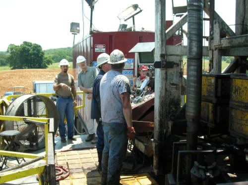
Southwestern Energy drilling operation in Van Buren County, Arkansas. Horizontal drilling and hydraulic stimulation techniques are utilized to tap natural gas resources from the Mississippian Fayetteville Shale. (Photo taken in 2007)
The Arkansas Geological Survey has completed and published an extensive geochemical research project on the Fayetteville Shale and has provided this information to the oil and gas industry and the public to assist with exploration and development projects. The study is available at the Arkansas Geological Survey as Information Circular 37 (Ratchford et al., 2006) and integrates surface and subsurface geologic information with organic geochemistry and thermal maturity data. The Arkansas Geological Survey continues to partner with the petroleum industry to pursue additional Fayetteville Shale related research. Ongoing research is focused on the chemistry and isotopic character of produced gases, mineralogy of the reservoir, and outcrop to basin modeling.
Production Data
Yearly gas production in South Arkansas

Yearly gas production in North Arkansas

For gas production information, please click the link below to download the spreadsheet:
![]() Yearly gas production in South Arkansas
Yearly gas production in South Arkansas
Upper Cambrian to Ordovician (Arbuckle, St. Peter, Fernvale)
Arbuckle Group
The term Arbuckle Group was first defined for the Arbuckle and Wichita Mountains of southern Oklahoma. The correlative Arbuckle Group in Arkansas is divided into seven formations in ascending order: Potosi, Eminence, Gasconade, Roubidoux, Jefferson City, Cotter, and Powell. The Arbuckle consists primarily of dolostone with minor amounts of limestone, sandstone and shale.
St. Peter Formation
The St. Peter sandstone, Middle Ordovician in age, is generally exposed throughout the northern counties in Arkansas. Its distribution in the subsurface is relatively unknown due to the lack of well control. The St. Peter is composed primarily of massive bedded, medium to fine grained, well rounded, friable, white sandstone. A few minor beds of shale, limestone, and/or dolostones have been noted in some sections. In the subsurface, the porosity of the sandstone varies from 9.8 to 13.5% in accordance with the relative cementation or secondary silification. No body fossils are known from the St. Peter in Arkansas, but a few trace fossils have been reported. The formation ranges from a feather edge to as much as 175 feet thick.
Fernvale Formation
The Upper Ordovician Fernvale limestone is widely exposed in the Salem Plateau of northern Arkansas in Izard, Stone, and Independence Counties. It consists generally of a massive, sometimes cross-bedded, coarsely crystalline, light gray to pink, crinoidal limestone. Various types of fossils are found throughout the formation, including orthoconic nautiloids, brachiopods, bryozoans, and crinoids. The thickness of the Fernvale ranges from 0 to over 100 feet. The porosity is reported 10% in the Cecil field of Crawford County. The Fernvale Formation in the Arkansas Valley area is stratigraphically equivalent to the Viola Formation in Oklahoma.
Silurian to Devonian (St. Clair, Penters, Sylamore)
St. Clair Formation
The Silurian St. Clair Formation is exposed in portions of Izard, Stone, Searcy and Independence Counties. The St. Clair is composed of a coarse-grained, highly fossiliferous, generally light gray to pinkish-gray limestone. The formation contains well preserved whole shells of brachiopods, ostracods, and trilobite pygidia and cephala. Fragmentary remains of crinoids, corals, bryozoa, bivalves, gastropods, and cephalopods are also found. The thickness of the St. Clair ranges from 0 to 100 feet. The St. Clair is stratigraphically equivalent to the Hunton Formation in Oklahoma.
Penters Formation
The Devonian Penters Formation is exposed at Penters Bluff in Independence County, which is its type locality, and in part of eastern Stone County along the White River. The Penters is composed principally of a fine-grained, fossiliferous, dolomitic, limestone with some chert and siliceous beds. The reservoir porosity ranges from 5 to 18%.
Sylamore Formation
The Sylamore Sandstone is a lower member of the Chattanooga Formation. The Sylamore is a gray, brown or white, fine to coarse-grained, slightly shaly, pyritic sandstone with angular to sub-rounded quartz grains. It is generally characterized by the presence of dark-colored phosphate pebbles. The Sylamore ranges from 0 to about 75 feet in outcrop thickness and the reservoir porosity ranges from 7 to 14%.
Mississippian (Boone, Fayetteville, Pitkin)
Boone Formation
The Boone Formation consists of gray, fine to coarse-grained fossiliferous limestone interbedded with brown, brownish-gray to dark gray dense chert. The quantity of chert varies considerably both vertically and horizontally. The Boone is well known for dissolutional features such as sinkholes, caves, and enlarged fissures. The thickness of the Boone is 300 to 350 feet in most of northern Arkansas but as much as 390 feet has been reported. The reservoir porosity ranges from 7 to 17%.
Fayetteville Formation
The Fayetteville Formation is composed mainly of a black, fissile, concretionary, clay shale. Dark gray, fine-grained limestones are commonly interbedded with the shales in north central Arkansas. The Wedington Sandstone Member consists of gray to brown, fine-grained, sometimes calcareous sandstone. As of March 2008, approximately 2.5 million acres in north central Arkansas have been leased in the Fayetteville Shale gas play with a cumulative production of approximately 107 BCF. The thickness of the producing zone (Lower Fayetteville Shale) ranges from 50 to 550 feet and wells range in depth from 1,500 to 6,500 feet.
Pitkin Formation
The Pitkin Formation is composed of a fine to coarse-grained, oolitic, bioclastic limestone. The Pitkin rests conformably on the underlying Fayetteville Shale. The thickness of the Pitkin ranges from a thin edge to over 400 feet. The reservoir porosity ranges from 7.5 to 12%.
Pennsylvanian (Morrow, Atoka, Hartshorne Coal)
Morrow Group
The Pennsylvanian Morrow Group is locally exposed in northwestern Arkansas where it is subdivided into the Bloyd Shale and the Hale Sandstone in descending stratigraphic order. Locally, the Morrow rests unconformably on the underlying Pitkin Formation, which makes a distinctive stratigraphic break between the Mississippian and Pennsylvanian systems in this area.
The Bloyd Formation consists of (in ascending stratigraphic order) the Brentwood Limestone Member, the Woolsey Member, the Dye Shale Member, the Kessler Limestone Member and the Trace Creek Shale Member. The typical thickness of the Bloyd ranges between 175 and 200 feet.
The Hale Formation consists mainly of sandstone and shale, but includes some beds of limestone and conglomerate. The formation is made up of two members: a lower Cane Hill Member and an upper Prairie Grove Member. The thickness of the Hale ranges from a few feet to more than 300 feet. The reservoir porosity of the Morrow Group ranges from 6 to 22%.
Atoka Group
The Pennsylvanian Atoka Formation is a sequence of marine, mostly tan to gray, silty sandstones and grayish-black shales. Some rare calcareous beds and siliceous shales are known. This unit has the largest areal extent of any of the Paleozoic formations in the state. In the Arkansas River Valley and the Frontal Ouachita Mountains the Atoka has been subdivided into upper, middle, and lower lithic members based on regionally mappable shale or sandstone sequences. This unit may reach up to 25,000 feet thick in the Ouachita Mountains region.
The principal producing and correlative sands of the Atoka Formation are the Carpenter "A", Upper Alma, Lower Alma, Carpenter "B", Morris, Areci, Freiberg, Casey, Dunn "A", Dunn "C", Paul Barton, Cecil Spiro, and Orr. The reservoir porosity of the Atoka ranges from 6 to 27%.
Lower Hartshorne Coal
The Lower Hartshorne coalbed lies in the lower portion of the McAlester Formation. It is the most extensive and productive coalbed in Arkansas. The Lower Hartshorne Coal is more than 14 inches thick over an area of about 740 square miles and is less than 14 inches thick in 580 additional square miles. West of Huntington in Sebastian County, it is approximately 8 feet thick. Coal rank ranges from low-volatile bituminous in the western part of the Arkansas Valley coalfield to semianthracite in the eastern part.
The development of Arkansas’ coalbed natural gas resources began in 2001 and has yielded an approximate cumulative production of 12 BCF from the Lower Hartshorne coalbed. In the gas producing area, the thickness of the coalbed ranges from 1 to 5 feet.